—compiled by Torben Jenk
with contributions from Denis Cooke, Ken Milano, Rich Remer, Hal
Schirmer, Dr. Robert Selig & others.
Press
coverage of the search to find British Redoubt No.
1 (online)
Revolutionary find at SugarHouse
site?, Kellie
Patrick Gates, PlanPhilly, Dec. 18, 2007.
SugarHouse to begin preliminary
construction, Kellie
Patrick Gates, PlanPhilly, Jan. 5, 2008.
Found! Ancient relic of an occupied
Phila., Dan
Rubin, Philadelphia Inquirer, Jan 10, 2008.
Can a Revolutionary War Fort Stop a
Casino?, Dan
Rubin, Philadelphia Inquirer blinq, Jan 10, 2008.
History Slows a
Casino, Dan
Rubin, Philadelphia Inquirer, Jan. 11, 1008.
Casino: Won't dig until Pa.
approves, Jeff
Shields, Philadelphia Inquirer, Jan 11,
2008.
Sizing up history of the SugarHouse
site, Kellie
Patrick Gates, Jan 16, 2008, includes a video of
Torben Jenk describing the evidence on the SugarHouse
site.
[Other articles in print include "They Need to Powwow"
Tony West, Philadelphia Public Record, Jan. 24, 2008;
"Don't underestimate significance of old British Fort"
Ken Milano, North Star, Jan. 24, 2008;
)
The spectacular 230 year old "Plan of the English Lines
Near Philadelphia 1777" by Lewis Nicola revealed at the
Historical Society of Pennsylvania.
Surveyed just
one month after the British Army left in June 1778,
Nicola's Plan provides the most spectacular visual
evidence of not just one redoubt but all ten, plus two
advanced redoubts, abatis, stockades, and cremaillered
work—the entire fortification between the Delaware
and Schuylkill Rivers. Nicola obviously wanted to learn
from the British Engineers, as we can today. Here are
some snapshot views with preliminary captions.
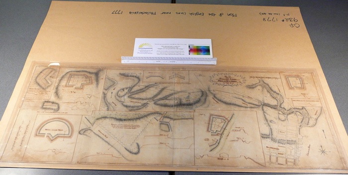
—"Plan
of the English Lines Near Philadelphia 1777" by Lewis
Nicola. Collection: Historical Society of Pennsylvania,
call # Of 932* 1778 p.3 (from Am. 602).
Scale for
Principal Plan 100 fathoms [600 feet] per inch.
Scale for Detach'd Plans 40 feet to an inch.
Scale for Detach'd Profils 20 feet to an
inch.
-----
The
importance of preservation and the examination original
documents. [opinion
written by Torben Jenk, Jan 11, 2008]
When the Nicola Plan was published in "The Narrative
& Critical History of America" (1888), editor Justin
Winsor cut out half the image. Amateur scanning in recent
years chopped off even more and was virtually illegible
but crucially, shared a fragment of evidence online. The
webmaster graciously provided the original source so the
illegible and truncated note could be read, "This plan of
the British works between the Delaware and Schuylkill is
sketched from the main portion of a drawing preserved in
the Penna. Hist. Society..."
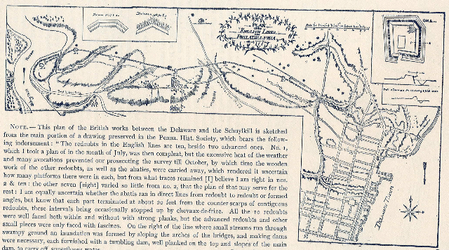
—Scan
of Plan of the
English Lines Philadelphia 1777 . Original
source "Narrative
and Critical History of America," Justin Winsor (Editor),
(Houghton, Mifflin & Co., Boston, 1887), Vol VI, p.
440. [Note, this
eight volume work was expanded to a sixteen volume work
by 1889 and it has been reprinted subsequently.] The
caption reads:
The
Historical Society of Pennsylvania has never suffered a
catastrophic fire or flood so what enters tends to
remain. If Nicola's Plan survived 110 years through 1888,
it was sure to survive 230 years until 2008—it
does. Let's learn from it.
-----
Redoubt No. 1 and its relationship to the Delaware
River. [opinion
written by Torben Jenk, Jan 11, 2008]
—Detail showing
Redoubt No. 1 from "Plan of the English Lines Near
Philadelphia 1777" by Lewis Nicola.
Scale for
Detach'd Plans 40 feet to an inch.
Scale for Detach'd Profils 20 feet to an
inch.
Note the "High Water" and "Low Water" marks and even the
slope of the underwater bank. The dotted line seems to
represent the grade line of the original soil, about ten
feet above low tide. Philadelphia has about a 6 foot
tidal range. By careful measuring it seems that the moat
/ trench around the redoubt would likely flood near high
tide, providing an extra layer of defense—mud or
ice—below those 12' long sharpened "pallisades" or
"fraise." I counted 153 of them.
The stockade into the river might have prevented the
enemy from floating downstream to the exposed side of the
Gun Battery and/or the entrance to the redoubt. Note that
there is no raised wooden platform on the southeast
corner (to the right of the entrance). Anyone floating
downstream could be fired upon by the northeast corner
("Thro. 3 - 4"), especially if they hit the stockade.
Those floating upstream would be fired upon by the Gun
Battery ("Through 1 - 2").
The dotted line seems to dispute the early 19th century
statements that the fort was on a mound, including
"Artillery Hill" and "Battery Hill." Maybe those early
travelers were too lazy to get out an examine the mound
and thereby discover it was an earthen doughnut. That
raises the issue that the earth from the redoubt was
probably not used to fill the riverbank, adjacent low
spots or the Cohocksink Creek. It went back into the
trench / moat.
Can proper archeology reveal, confirm or challenge these
seemingly unique details? Do we know if and how Nicola's
survey was used to teach the Continental Army? Should
Redoubt #1 be considered a British or early American
engineering landmark?
-----
First
attempt to transpose the measurements from Nicola's Plan
(1778) on to a Bromley Atlas (1895) and to today (2008).
[opinion
written by Torben Jenk, Jan 11, 2008]
Nicola shows
the center of Redoubt No. 1 to be in a line with the
ancient causeway and bridge [Laurel Street] and about 100
fathoms [600 feet] from the bridge over the Cohocksink
[basically Laurel and Canal Streets] and about 210
fathoms [1,260 feet] from Front & Laurel Streets.
In 1830, John
F. Watson wrote:
"The British redoubts remained til lately—one
on the Delaware bank in a line with the stone-bridge
street—then no houses were near it; now it is all
built up, and streets are run where none were
seen."
Scaled at 200' to an inch, 100 fathoms (600 feet) would
be three inches on the Bromley, so the fort should be
somewhere near the eastern edge of the rail yards of the
Shackamaxon Freight Station. Foundations aren't needed
for rail tracks yet archeologists, unaware of the
potential, might confuse rotting 19th century railroad
sleepers or other pier pilings with something much more
ancient, like the wooden structure which contained the
earthen walls of Redoubt No. 1, or the 12' long sharpened
"pallisades" or "fraise." Few would have survived intact
even in 1800, as locals probably recycled them into other
structures or burned them.
If not exactly at that spot, Nicola's map shows Redoubt
No. 1 definitely on the 22.6 acre SugarHouse site. Here
is some photographic evidence. My goal remains to help
the archeologists find Redoubt No. 1. Using factual
evidence like this, surely we can define a mere 1/2 acre
on the 22.6 acre site, for close examination.

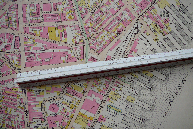
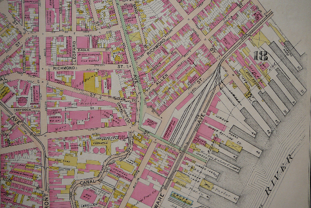
—Detail
showing Redoubts No. 1 - 6 from "Plan of the English
Lines Near Philadelphia 1777" by Lewis Nicola.
Collection: Historical Society of
Pennsylvania.
Scale for Principal Plan 100 fathoms [600 feet] per
inch.
Redoubt No. 1 is near bottom right. Redoubts 1 & 2
were then divided by the Cohocksink Creek which was
traversed by a causeway and bridge [now Laurel Street].
Front Street is the first street west (left) of the
Cohocksink and it splits left up the Germantown Road or
right over Laurel Street.
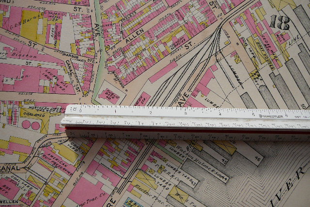
—Detail,
1895 Bromley Atlas, Plate 13 (200 feet / inch)
In a line with Laurel Street
0" = Canal & Laurel Streets
3" = 100 fathoms = 600 feet = likely location of Redoubt
No. 1 (at the edge of the railroad tracks near "AVE").
—Detail,
1895 Bromley Atlas, Plate 13 (200 feet /
inch):
In a line with Laurel Street
0" = Front & Laurel Streets
3-1/2" = 116 fathoms = 700' = Laurel & Canal
6-3/8" = 210 fathoms = 1,260 feet = likely location of
Redoubt No. 1 (at the edge of the railroad tracks near
"AVE").
—Detail
1895 Bromley, Plate
13.
Besides the "Shackamaxon Freight Sta." west of the rail
tracks, also note the various industries along the piers:
including
#53 "Kindling Wood"
#51 "Saw Mill"
#50 "Cedar Ware"
#49 "Boat Houses & Coal Yard"
between piers "C & A R.R. Ferry" [line of Shackmaxon
Street and northeastern boundary of SugarHouse Casino
site]
#48 "Lumber"
#46 "Penna. Sugar Refining Co."
#45 "Foundry Supplies"
#44 "Watson & Malone & Sons, Lumber"
#43 "P&RRR Co. Lumber Yard"
#42 "Wm. S. Taylor, Lumber Yard"
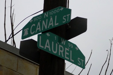
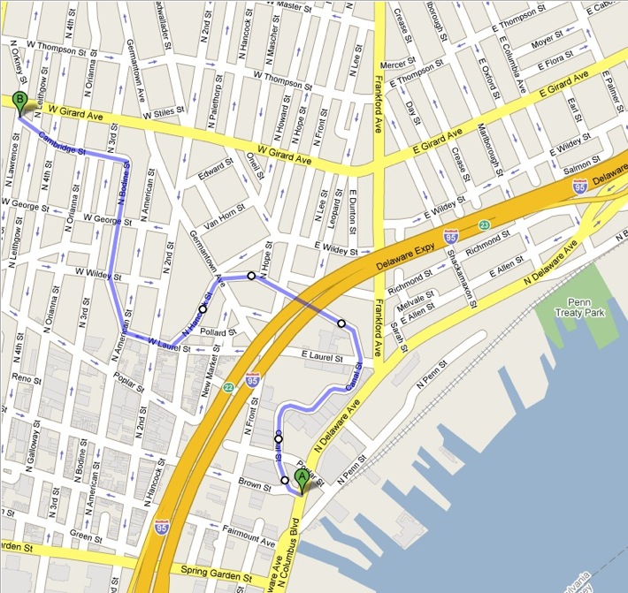
—Street signs where Canal
& Laurel meet in 2008.
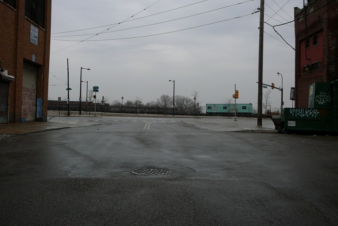
Looking east from the intersection of Canal & Laurel
Streets along the line of Laurel Street (2008). The
traffic light signifies the intersection of the ancient
"Road to Frankford" (heading left / north) and Delaware
Avenue (following the northeasterly bend of the river).
The green construction trailer sits on the SugarHouse
site. The northeast corner of the SugarHouse site, along
the Delaware River, is near the tall trees in the distant
center. Nicola's Plan says the Redoubt No. 1 stood
approximately 600 feet from the intersection of Canal
& Laurel Streets. The tall trees are about 800 -
1,000 feet from Canal & Laurel (access to the
SugarHouse site is restricted by fences and guards).
—Map
created on Google Map.
Despite being
turned into a canal and then a sewer, the lower parts of
the Cohocksink are clearly evident under parts of the
streets we know today as Canal, Allen, Hancock, Laurel,
Bodine, Cambridge and Orkney; and in the oddly-shaped
buildings which straddle the creek. Point A is near Pier
35, Point B is where the creek crosses under Girard
Avenue. The Governor's
Mill stood
northeast of the ninety degree bend from Cambridge to
Bodine Street. The area below the Frankford Road but east
of the Cohocksink Creek to the Delaware River was known
in Colonial times as "Point Pleasant."
-----
Douglas
McLearen, PHMC, calls for "no ground disturbing
activities" (Jan 7, 2008)
On January 7, 2008, Douglas McLearen of the Pennsylvania
Historical & Museum Commission wrote to Terrence
McKenna of The Keating Group (contractors at SugarHouse)
and James Boyer of the U.S. Army Corps of Engineers
stating: "It is the opinion of the State Historic
Preservation Office that there should be no
ground-disturbing activities on the [SugarHouse] site
other than those related to archaeology until the 106
process is over. We are still in consultation."
As one of the advocates for proper archeology at the 22.6
acre SugarHouse site, Torben Jenk wrote to Mr. McLearen
on January 10:
Thank you for
recommending "no ground-disturbing activities on the
[SugarHouse] site other than those related to archeology
until the 106 process is over."
On December 12 I notified A. D. Marble of the possibility
of finding British Redoubt #1 on the SugarHouse site. For
weeks, the "professionals" under contract or supervising
this process have ignored my emails and the evidence
which I and others have researched and loaded to the
webpage at http://www.workshopoftheworld.com/kensington/point_archeology.html
. Every
item was cited and referenced in a scholarly fashion.
I even highlighted where to look for the best
evidence.
I was appalled
when a "site grading permit" was issued last week. Site
grading could have removed all evidence of this British
Redoubt #1 before the meeting on Jan 18 about the 106
process. As I have stated repeatedly to others, including
James Boyer, "How can A.D. Marble find Native American
artifacts on the SugarHouse site but find nothing from
British Redoubt No. 1? Because they aren't looking for
it."
Others have shown more interest, including Dan Rubin who
wrote an article in today's Inquirer "Found! Ancient relic of an occupied
Phila."
As I have
stated since mid December, finding Reboubt No. 1 would
reveal 18th century British military engineering, so
admired by Major General Charles Lee of the Continental
Army in America, who had bitterly complained of the
incompetence of American engineers, remarking that "we
had not an officer who knew the difference between a
chevaux-de-frise and a cabbage garden."
The "officers" and engineers of today seem no better.
This survey of British Redoubt No. 1, done just one month
after the British left in June 1778, shows 153 Chevaux de
Frises. Redoubt No. 1 was surveyed so expertly by Lewis
Nicola for one reason, he wanted to learn from the
British Engineers. Nicola's original survey survives in
spectacular condition and reveals the exact locations and
construction details of this entire line of defenses. Our
voluntary corps of researchers, led by Dr. Robert Selig
and myself, has already assembled over 250 factual
historical items about British Redoubt No. 1 including
maps, surveys, images and narratives. From these and our
on-going research, we can learn from and celebrate this
oft-forgotten 10 months of American history.
Thank you for stopping the site-grading. We look forward
to collaborating with you to reveal this buried
treasure.
-----